Analysis Overview — all analysis types in one page
Experiments
- Baseline — validation
- CMEMS — validation
- CMEMS_prof — validation
- NetSW_LW — validation
- ObsKd — validation
- TPXO9 — tidal
- mle_comparison — mle_comparison
Atlantic Margin Model 7 km (AMM7)
Domain Description
AMM7 is a regional ocean model covering the northwest European continental shelf, from the Iberian Peninsula in the south to the Norwegian Sea in the north. It encompasses the North Sea, English Channel, Celtic Sea, Bay of Biscay, and the shelf break into the northeast Atlantic.
Geographic Coverage
- Latitude: 40.1°N to 64.9°N
- Longitude: 19.8°W to 12.9°E
- Resolution: ~1/12° spherical grid (~7 km)
- Vertical: 40 generalised vertical coordinate (GVC) levels
Key Features
- Bathymetry from GEBCO with Beckmann–Haidvogel smoothing
- Open boundaries driven by CMEMS NWS AMM7 MY reanalysis (historical) or CMIP6 delta-change (future projections)
- Rivers from EMORID (historic) or CMIP6 (future)
- Tidal forcing from TPXO9-atlas (13 constituents)
Observation Datasets
| Dataset | Variables | Period | Type |
|---|---|---|---|
| ICES hydrographic database | Temperature, Salinity | 1993– | Cruise CTD / bottle |
| ARGO floats (Ifremer/GDAC) | Temperature, Salinity | 2000– | Autonomous profilers |
| OSTIA / CMEMS SST | Sea surface temperature | 2003– | Level 4 satellite analysis |
| FES2014 / TPXO9 | Tidal constituents | — | Barotropic tidal model |
Cross-experiment Summary
Surface
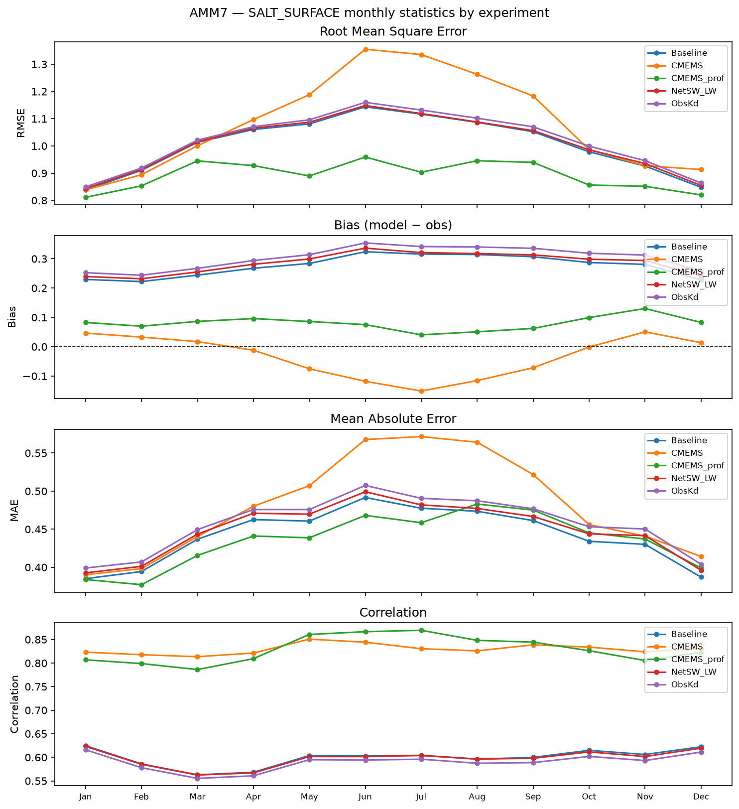
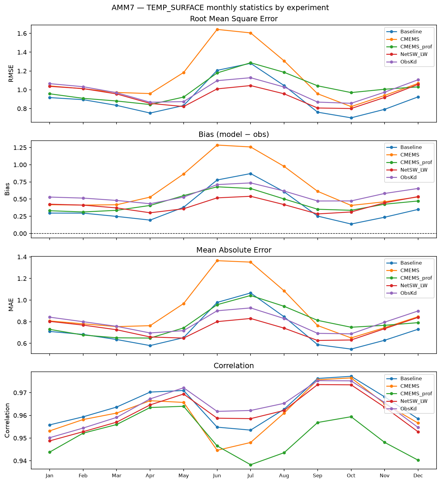
3D
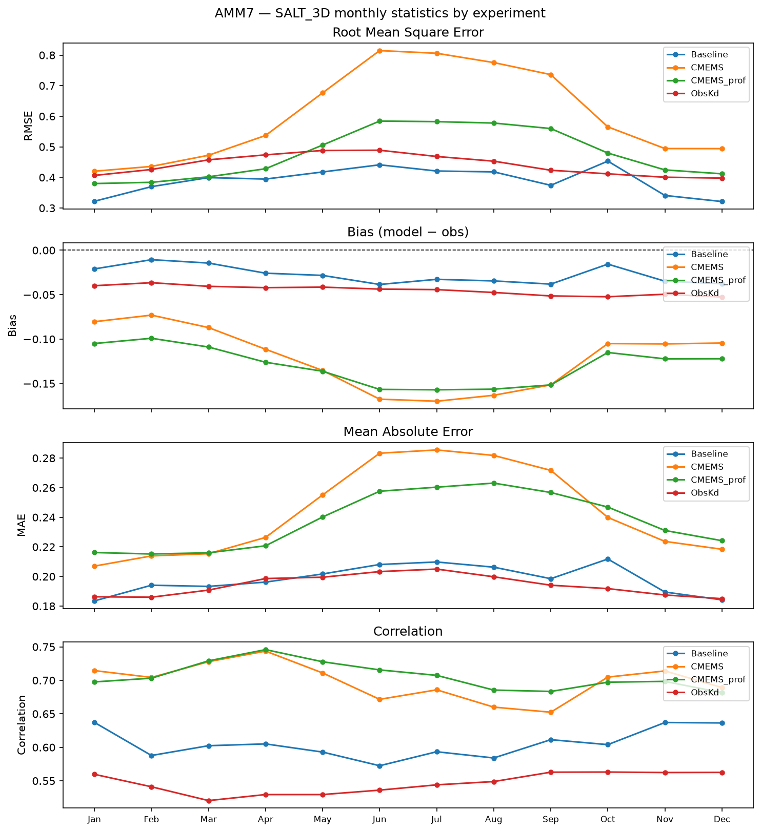
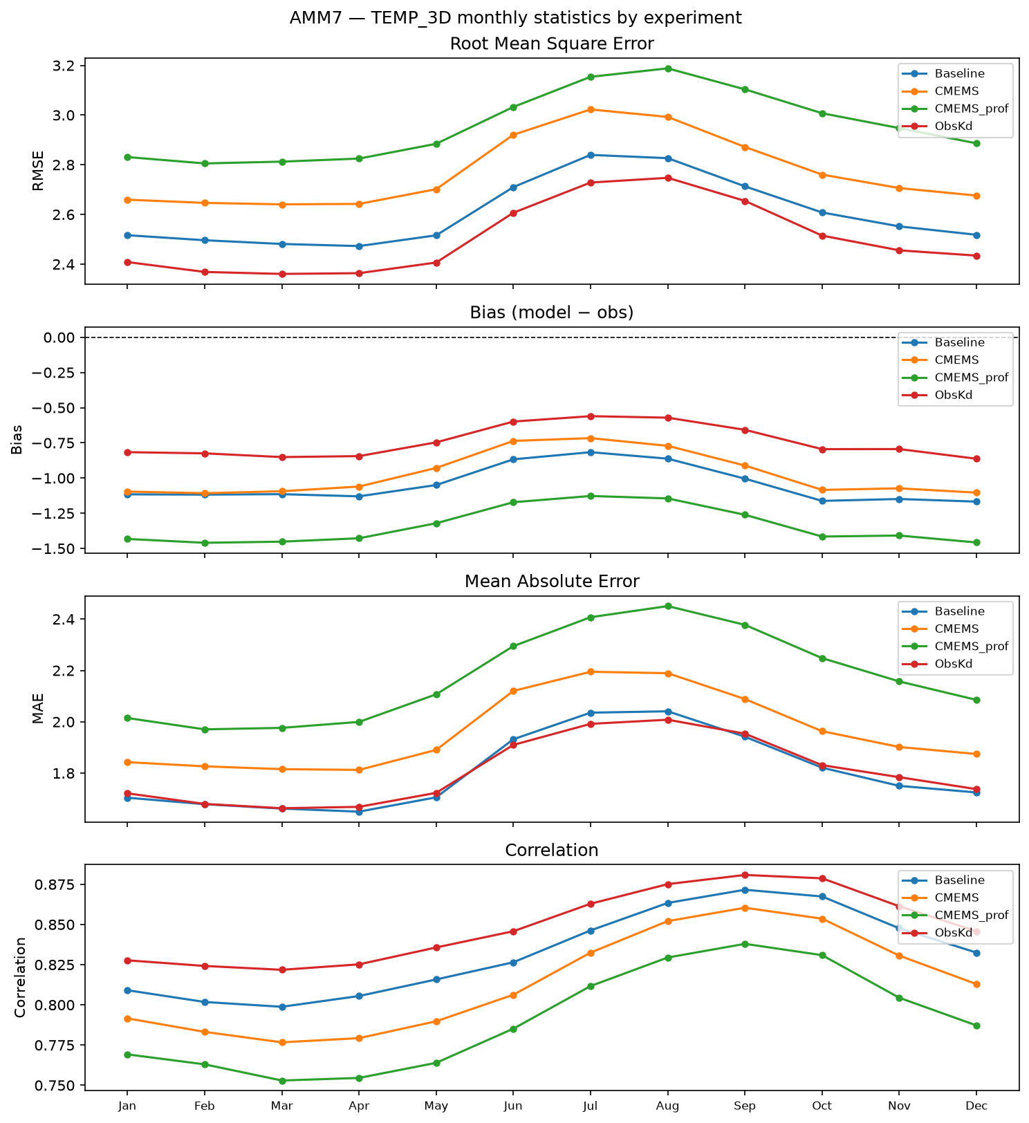
How Input Files Were Generated
Future ocean boundary conditions use CMIP6 model output as the climate-change signal on top of the historical CMEMS AMM7 reference.
Scenario Summary
MPI-ESM1-2-HR
| Boundary type | SSP5-8.5 |
|---|---|
| Tidal mean state (2-D) | zos, uo, vo |
| 3-D delta-change | thetao, so, uo, vo |
Bathymetry
Bathymetry
Regridded conservatively from GEBCO onto the AMM7 ~1/12° spherical grid using bathymetry-regrid (ocean-prep), with Beckmann-Haidvogel smoothing (rx0 ≤ 0.2). Output: amm7_topo_getm.nc with variables lon, lat, mask, H.
Config not yet committed.
bathymetry-regrid --config config/amm7_bathy_create.yaml
Boundary Conditions
CMEMS historical boundaries (T, S, SSH, currents)
NWS AMM7 MY reanalysis (1993–present) providing hourly barotropic and daily baroclinic boundary conditions. Processed with ocean-prep run_cmems_boundaries.
Config not yet committed.
python cli/run_cmems_boundaries.py --config config/amm7_bdy_create.yaml
Tidal boundaries (TPXO9 + CMIP6 mean SSH / barotropic transport)
TPXO9-atlas (13 constituents) tidal prediction for zos, uo, vo combined with CMIP6 monthly mean sea-surface height and depth-integrated barotropic transport. Scenario-specific; see Scenario Summary table below.
Config not yet committed.
run-tidal-boundaries --config config/amm7_tidal_bdy.yaml
3-D delta-change boundaries (T, S and optionally currents)
Future 3-D boundary conditions via the delta-change method: AMM7 historical CMEMS reference cycled over the output period, with a CMIP6 monthly change signal (future 20-yr climatology minus historical 1985–2014 climatology) added at each boundary point. Scenario-specific; see Scenario Summary table below.
AMM7 delta-change boundary config
Config not yet committed.
run-delta-boundaries --config config/amm7_delta_bdy.yaml --scenario ssp585
Initial Conditions
Initial conditions (temperature, salinity)
Monthly snapshots (1st of each month) from CMEMS NWS AMM7 MY reanalysis. Flood-fill propagates valid values into any remaining NaN cells on the model grid.
AMM7 initial conditions config
Config not yet committed.
python cli/download_init_conditions.py --config config/amm7_init_create.yaml --source AMM7 --year 2015